# datasette-leaflet-geojson
[](https://pypi.org/project/datasette-leaflet-geojson/)
[](https://github.com/simonw/datasette-leaflet-geojson/releases)
[](https://github.com/simonw/datasette-leaflet-geojson/actions?query=workflow%3ATest)
[](https://github.com/simonw/datasette-leaflet-geojson/blob/main/LICENSE)
Datasette plugin that replaces any GeoJSON column values with a Leaflet map
## Installation
Install this plugin in the same environment as Datasette.
$ datasette install datasette-leaflet-geojson
## Usage
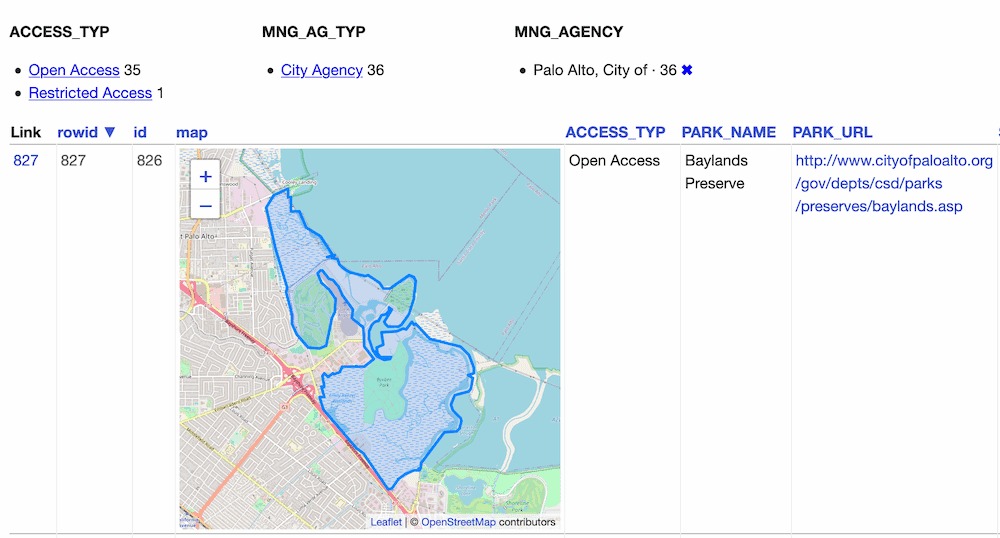
Any columns containing valid GeoJSON strings will have their contents replaced with a Leaflet map when they are displayed in the Datasette interface.
## Demo
You can try this plugin out at https://calands.datasettes.com/calands/superunits_with_maps
## Configuration
By default this plugin displays maps for the first ten rows, and shows a "Click to load map" prompt for rows past the first ten.
You can change this limit using the `default_maps_to_load` plugin configuration setting. Add this to your `metadata.json`:
```json
{
"plugins": {
"datasette-leaflet-geojson": {
"default_maps_to_load": 20
}
}
}
```
Then run Datasette with `datasette mydb.db -m metadata.json`.
Raw data
{
"_id": null,
"home_page": "https://github.com/simonw/datasette-leaflet-geojson",
"name": "datasette-leaflet-geojson",
"maintainer": null,
"docs_url": null,
"requires_python": null,
"maintainer_email": null,
"keywords": null,
"author": "Simon Willison",
"author_email": null,
"download_url": "https://files.pythonhosted.org/packages/0f/80/914c65057714798c97bdcdaaa480dcdcb94c246358d00cd185e9e9c91fa1/datasette_leaflet_geojson-0.8.2.tar.gz",
"platform": null,
"description": "# datasette-leaflet-geojson\n\n[](https://pypi.org/project/datasette-leaflet-geojson/)\n[](https://github.com/simonw/datasette-leaflet-geojson/releases)\n[](https://github.com/simonw/datasette-leaflet-geojson/actions?query=workflow%3ATest)\n[](https://github.com/simonw/datasette-leaflet-geojson/blob/main/LICENSE)\n\nDatasette plugin that replaces any GeoJSON column values with a Leaflet map\n\n## Installation\n\nInstall this plugin in the same environment as Datasette.\n\n $ datasette install datasette-leaflet-geojson\n\n## Usage\n\nAny columns containing valid GeoJSON strings will have their contents replaced with a Leaflet map when they are displayed in the Datasette interface.\n\n## Demo\n\nYou can try this plugin out at https://calands.datasettes.com/calands/superunits_with_maps\n\n\n\n## Configuration\n\nBy default this plugin displays maps for the first ten rows, and shows a \"Click to load map\" prompt for rows past the first ten.\n\nYou can change this limit using the `default_maps_to_load` plugin configuration setting. Add this to your `metadata.json`:\n\n```json\n{\n \"plugins\": {\n \"datasette-leaflet-geojson\": {\n \"default_maps_to_load\": 20\n }\n }\n}\n```\nThen run Datasette with `datasette mydb.db -m metadata.json`.\n",
"bugtrack_url": null,
"license": "Apache License, Version 2.0",
"summary": "A Datasette plugin that renders GeoJSON columns using Leaflet",
"version": "0.8.2",
"project_urls": {
"Homepage": "https://github.com/simonw/datasette-leaflet-geojson"
},
"split_keywords": [],
"urls": [
{
"comment_text": "",
"digests": {
"blake2b_256": "a342f119c40f5e436300a3ae8bc9e23e6667c6964da5974238bf05298b2f0a59",
"md5": "8481a71a27f211e996cfd9f33d40dfda",
"sha256": "cbc64db5c6ec8d75de2c3390e6ce0cc680ab71105434692aad5e7400393a8a24"
},
"downloads": -1,
"filename": "datasette_leaflet_geojson-0.8.2-py3-none-any.whl",
"has_sig": false,
"md5_digest": "8481a71a27f211e996cfd9f33d40dfda",
"packagetype": "bdist_wheel",
"python_version": "py3",
"requires_python": null,
"size": 5056,
"upload_time": "2024-04-25T05:05:32",
"upload_time_iso_8601": "2024-04-25T05:05:32.926957Z",
"url": "https://files.pythonhosted.org/packages/a3/42/f119c40f5e436300a3ae8bc9e23e6667c6964da5974238bf05298b2f0a59/datasette_leaflet_geojson-0.8.2-py3-none-any.whl",
"yanked": false,
"yanked_reason": null
},
{
"comment_text": "",
"digests": {
"blake2b_256": "0f80914c65057714798c97bdcdaaa480dcdcb94c246358d00cd185e9e9c91fa1",
"md5": "8fbfe06ce86e2714284f44626612d9ce",
"sha256": "d72e5390b7cb3bafcc8792d1353e053165920876d56ee6185c7b4480bbec6d06"
},
"downloads": -1,
"filename": "datasette_leaflet_geojson-0.8.2.tar.gz",
"has_sig": false,
"md5_digest": "8fbfe06ce86e2714284f44626612d9ce",
"packagetype": "sdist",
"python_version": "source",
"requires_python": null,
"size": 4998,
"upload_time": "2024-04-25T05:05:34",
"upload_time_iso_8601": "2024-04-25T05:05:34.401026Z",
"url": "https://files.pythonhosted.org/packages/0f/80/914c65057714798c97bdcdaaa480dcdcb94c246358d00cd185e9e9c91fa1/datasette_leaflet_geojson-0.8.2.tar.gz",
"yanked": false,
"yanked_reason": null
}
],
"upload_time": "2024-04-25 05:05:34",
"github": true,
"gitlab": false,
"bitbucket": false,
"codeberg": false,
"github_user": "simonw",
"github_project": "datasette-leaflet-geojson",
"travis_ci": false,
"coveralls": false,
"github_actions": true,
"lcname": "datasette-leaflet-geojson"
}

