# geopedestrian-py
Determines which locations are reachable by a pedestrian.

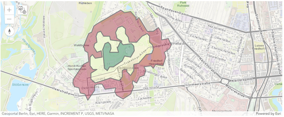
*Walking areas 5, 10, and 15 minutes for a pedestrian starting at the Olympiastadium in Berlin, Germany.*
Raw data
{
"_id": null,
"home_page": null,
"name": "geopedestrian",
"maintainer": null,
"docs_url": null,
"requires_python": ">=3.7",
"maintainer_email": null,
"keywords": "geospatial, intelligence, urban, digital twin, walking, routing",
"author": null,
"author_email": null,
"download_url": "https://files.pythonhosted.org/packages/8b/ad/0ff60c13dc11e6f270231de10e72e51da895725e88dc08a7299e658f3238/geopedestrian-0.1.tar.gz",
"platform": null,
"description": "# geopedestrian-py\nDetermines which locations are reachable by a pedestrian.\n\n\n\n*Walking areas 5, 10, and 15 minutes for a pedestrian starting at the Olympiastadium in Berlin, Germany.*\n",
"bugtrack_url": null,
"license": null,
"summary": "Determines which locations are reachable by a pedestrian.",
"version": "0.1",
"project_urls": {
"Documentation": "https://geopedestrian.readthedocs.io/en/latest",
"GitHub": "https://github.com/Geospatial-AI-DE/geopedestrian-py",
"Homepage": "https://geospatial-ai.de"
},
"split_keywords": [
"geospatial",
" intelligence",
" urban",
" digital twin",
" walking",
" routing"
],
"urls": [
{
"comment_text": "",
"digests": {
"blake2b_256": "1b1951529d9124c3e0b72f8a9f544113b5d0b05c28f1430e0f7feb6cac92fe78",
"md5": "dd877f46a9d8ae258f5c444b2ab3a548",
"sha256": "02475572b3403abed24e08cac62c63a3e330e6a230ee3a559f681fd29f17411a"
},
"downloads": -1,
"filename": "geopedestrian-0.1-py3-none-any.whl",
"has_sig": false,
"md5_digest": "dd877f46a9d8ae258f5c444b2ab3a548",
"packagetype": "bdist_wheel",
"python_version": "py3",
"requires_python": ">=3.7",
"size": 23890,
"upload_time": "2024-07-21T14:35:17",
"upload_time_iso_8601": "2024-07-21T14:35:17.700488Z",
"url": "https://files.pythonhosted.org/packages/1b/19/51529d9124c3e0b72f8a9f544113b5d0b05c28f1430e0f7feb6cac92fe78/geopedestrian-0.1-py3-none-any.whl",
"yanked": false,
"yanked_reason": null
},
{
"comment_text": "",
"digests": {
"blake2b_256": "8bad0ff60c13dc11e6f270231de10e72e51da895725e88dc08a7299e658f3238",
"md5": "1719ebbceadc03558e988cc66302c1a3",
"sha256": "c43a38ffae4394ae88aea3dc00545eadb9e5725b005b61ce114a23aef264cf84"
},
"downloads": -1,
"filename": "geopedestrian-0.1.tar.gz",
"has_sig": false,
"md5_digest": "1719ebbceadc03558e988cc66302c1a3",
"packagetype": "sdist",
"python_version": "source",
"requires_python": ">=3.7",
"size": 35910,
"upload_time": "2024-07-21T14:35:19",
"upload_time_iso_8601": "2024-07-21T14:35:19.370307Z",
"url": "https://files.pythonhosted.org/packages/8b/ad/0ff60c13dc11e6f270231de10e72e51da895725e88dc08a7299e658f3238/geopedestrian-0.1.tar.gz",
"yanked": false,
"yanked_reason": null
}
],
"upload_time": "2024-07-21 14:35:19",
"github": true,
"gitlab": false,
"bitbucket": false,
"codeberg": false,
"github_user": "Geospatial-AI-DE",
"github_project": "geopedestrian-py",
"travis_ci": false,
"coveralls": false,
"github_actions": false,
"lcname": "geopedestrian"
}
