| Name | geourban JSON |
| Version |
0.1
 JSON
JSON |
| download |
| home_page | |
| Summary | Direct access to simulated spatially enabled traffic grids of urban regions. |
| upload_time | 2024-01-09 22:42:30 |
| maintainer | |
| docs_url | None |
| author | |
| requires_python | >=3.7 |
| license | |
| keywords |
geospatial
intelligence
urban
digital twin
|
| VCS |
 |
| bugtrack_url |
|
| requirements |
No requirements were recorded.
|
| Travis-CI |
No Travis.
|
| coveralls test coverage |
No coveralls.
|
[](https://pypi.org/project/geourban)

[](https://geourban.readthedocs.io/en/latest)
[](https://twitter.com/intent/tweet?text=Outstanding:&url=https%3A%2F%2Fgithub.com%2FGeospatial-AI-DE%geourban-py)
# Geospatial Urban API Service
Direct access to simulated spatially enabled traffic grids of urban regions. This modern Python module represents an idiomatic client accessing the [Geospatial Urban API](https://geospatial-ai.de/?rara-portfolio=geospatial-urban-api-service) being hosted on [Rapid API](https://rapidapi.com/gisfromscratch/api/geourban).
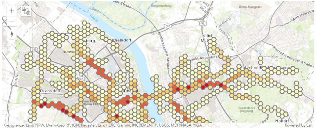
*Traffic grid accumulating the number of simulated agents moving using bikes through the city of Bonn between 07:00 and 08:00 AM*
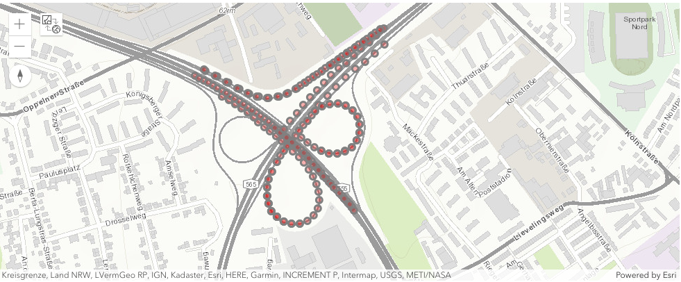
*Simulated agent positions moving by car within a distance of 250 meters of a highway cross road intersection being located at (50.746708, 7.074405) in the city of Bonn starting at 08:00 AM and lasting 30 seconds*
## Why is it important?
The geospatial urban API solves a common challenge for urban digital twins – obtaining insights into mobility behavior of citizens using simulated traffic scenarios. Traffic planners use powerful tools in shaping urban mobility sustainable. But without having access to citizen movement profiles there is always a need for simulating, analyzing, testing and mitigating traffic scenarios.
## Next steps
Please, check out the [RapidAPI Account Creation and Management Guide](https://docs.rapidapi.com/docs/account-creation-and-settings).
Start with the [Introduction](https://rapidapi.com/gisfromscratch/api/geourban/details) section for further information.
Follow the [Guides](https://geourban.readthedocs.io/en/latest/guides.html) or take a look at the [Urban Traffic Bonn](https://github.com/Geospatial-AI-DE/geourban-py/blob/main/notebooks/Urban%20Traffic%20Bonn.ipynb) notebook.
## Ready to use
The geospatial urban API offer ready-to-use geospatial features representing simulated spatially enabled traffic grids of urban regions.
Every geospatial result support the GeoJSON and Esri FeatureSet format out of the box. For best sustainability, the serverless cloud-backend queries the geospatial features from a big data store. You can use these geospatial features to build various mapping and geospatial applications.
Raw data
{
"_id": null,
"home_page": "",
"name": "geourban",
"maintainer": "",
"docs_url": null,
"requires_python": ">=3.7",
"maintainer_email": "",
"keywords": "geospatial,intelligence,urban,digital twin",
"author": "",
"author_email": "",
"download_url": "https://files.pythonhosted.org/packages/f7/66/d5654148cffe80c3be33e059dadf9cd66f5c9128bf701e372f01b5c73b48/geourban-0.1.tar.gz",
"platform": null,
"description": "[](https://pypi.org/project/geourban)\n\n[](https://geourban.readthedocs.io/en/latest)\n[](https://twitter.com/intent/tweet?text=Outstanding:&url=https%3A%2F%2Fgithub.com%2FGeospatial-AI-DE%geourban-py)\n\n\n# Geospatial Urban API Service\nDirect access to simulated spatially enabled traffic grids of urban regions. This modern Python module represents an idiomatic client accessing the [Geospatial Urban API](https://geospatial-ai.de/?rara-portfolio=geospatial-urban-api-service) being hosted on [Rapid API](https://rapidapi.com/gisfromscratch/api/geourban).\n\n\n\n\n*Traffic grid accumulating the number of simulated agents moving using bikes through the city of Bonn between 07:00 and 08:00 AM*\n\n\n\n\n*Simulated agent positions moving by car within a distance of 250 meters of a highway cross road intersection being located at (50.746708, 7.074405) in the city of Bonn starting at 08:00 AM and lasting 30 seconds*\n\n## Why is it important?\nThe geospatial urban API solves a common challenge for urban digital twins \u2013 obtaining insights into mobility behavior of citizens using simulated traffic scenarios. Traffic planners use powerful tools in shaping urban mobility sustainable. But without having access to citizen movement profiles there is always a need for simulating, analyzing, testing and mitigating traffic scenarios.\n\n## Next steps\nPlease, check out the [RapidAPI Account Creation and Management Guide](https://docs.rapidapi.com/docs/account-creation-and-settings).\n\nStart with the [Introduction](https://rapidapi.com/gisfromscratch/api/geourban/details) section for further information.\n\nFollow the [Guides](https://geourban.readthedocs.io/en/latest/guides.html) or take a look at the [Urban Traffic Bonn](https://github.com/Geospatial-AI-DE/geourban-py/blob/main/notebooks/Urban%20Traffic%20Bonn.ipynb) notebook.\n\n## Ready to use\nThe geospatial urban API offer ready-to-use geospatial features representing simulated spatially enabled traffic grids of urban regions. \n\nEvery geospatial result support the GeoJSON and Esri FeatureSet format out of the box. For best sustainability, the serverless cloud-backend queries the geospatial features from a big data store. You can use these geospatial features to build various mapping and geospatial applications.\n",
"bugtrack_url": null,
"license": "",
"summary": "Direct access to simulated spatially enabled traffic grids of urban regions.",
"version": "0.1",
"project_urls": {
"Documentation": "https://geourban.readthedocs.io/en/latest",
"GitHub": "https://github.com/Geospatial-AI-DE/geourban-py",
"Homepage": "https://geospatial-ai.de"
},
"split_keywords": [
"geospatial",
"intelligence",
"urban",
"digital twin"
],
"urls": [
{
"comment_text": "",
"digests": {
"blake2b_256": "6b658154e90916d7b57f1419040bcc8ce9203ad2eb15a25179b0d19fb85a412d",
"md5": "5669959ceee6b9005c7d5630aecd9a38",
"sha256": "e4d94b59d6bd74931dcee724f9b19a56ef656afec79a1587020f1f98c9561301"
},
"downloads": -1,
"filename": "geourban-0.1-py3-none-any.whl",
"has_sig": false,
"md5_digest": "5669959ceee6b9005c7d5630aecd9a38",
"packagetype": "bdist_wheel",
"python_version": "py3",
"requires_python": ">=3.7",
"size": 10310,
"upload_time": "2024-01-09T22:42:28",
"upload_time_iso_8601": "2024-01-09T22:42:28.516697Z",
"url": "https://files.pythonhosted.org/packages/6b/65/8154e90916d7b57f1419040bcc8ce9203ad2eb15a25179b0d19fb85a412d/geourban-0.1-py3-none-any.whl",
"yanked": false,
"yanked_reason": null
},
{
"comment_text": "",
"digests": {
"blake2b_256": "f766d5654148cffe80c3be33e059dadf9cd66f5c9128bf701e372f01b5c73b48",
"md5": "426ca33698d7541d9d9e1b654c37bbb6",
"sha256": "37b055d86a1a20b58bb0bc946b71b52941d25af3d1292d350e3849a24e62cb2c"
},
"downloads": -1,
"filename": "geourban-0.1.tar.gz",
"has_sig": false,
"md5_digest": "426ca33698d7541d9d9e1b654c37bbb6",
"packagetype": "sdist",
"python_version": "source",
"requires_python": ">=3.7",
"size": 25959,
"upload_time": "2024-01-09T22:42:30",
"upload_time_iso_8601": "2024-01-09T22:42:30.460234Z",
"url": "https://files.pythonhosted.org/packages/f7/66/d5654148cffe80c3be33e059dadf9cd66f5c9128bf701e372f01b5c73b48/geourban-0.1.tar.gz",
"yanked": false,
"yanked_reason": null
}
],
"upload_time": "2024-01-09 22:42:30",
"github": true,
"gitlab": false,
"bitbucket": false,
"codeberg": false,
"github_user": "Geospatial-AI-DE",
"github_project": "geourban-py",
"travis_ci": false,
"coveralls": false,
"github_actions": false,
"lcname": "geourban"
}
